Volleyball the summit of Mount Blanc I kept these memories of our trip in Spiti last year that I had to go back. The reception was so nice, I brought the pictures taken at school to return to the instit. 25 km, there is little in 3 hours. Villages and Langja Hikkim are still beautiful, with Cho Cho Kang Nilda (6300m) in the background.

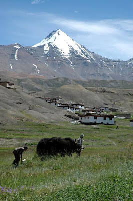
 Komic village below the monastery
  The school next to the monastery (Summer 2007)
Moment of doubt arrival at the monastery, desert ... and starts. We can see just qqs Indian workers who barely meet our "hello" and "namaste". Nobody seems to speak English. Well ... It still manages to get some water to fill the water bottles. It changes the atmosphere and hospitality last year. The school seems abandoned. A little later, there emerges a monk who tells us somehow that there are ceremonies at Kaza for 2-3 days. The teacher is also absent. But no problem to stay in the guesthouse of the monastery. Qqs Indian workers finally come to meet us, intrigued by our horses, and excited to try a bike with gears.

Komic is at 4500m altitude (only higher than the Vallot refuge!). It feels great. A small pass tempting teasing us just above. You think about what I think? Ok, let's go!


Our first pass above 4500m (4662m):

the evening, won by the euphoria, we engage in frenzied games of volleyball, Sophie in the Indian workers equipped with beautiful eyes, me with novices red caps and yellow. Good laugh. Results: 2-1 for the Indians, a little annoyed at having lost heritage, and beautiful blue qqs wrists! It's time to go eat. Soup - rice - dal (lentils =) - chapati, nothing very original (uh, except the eggs in the soup ...).


We acknowledge the scope of altitude after the fact, that was not all that much sense. Sore skull punctured the night and well the next day!
A young Indian explains in his limited English that comes from the Delhi region. It's there for the summer, only to work and earn some money to bring his family. He does not like altitude, mountain, sun, heat the day, cold night, the food of the monastery, his work on the site. The town, his family, his friends are missing. They are apparently thousands to come and work in the summer Roads and yards of the Himalayas, Bihar and Nepal to outposts in the toughest tasks. Food and lodging (in tents on the edge of the road) more than 60 rupees per day (slightly less than 1 euro), the minimum wage proposed by the government. They are often treated with much contempt as belonging to lower castes. Gandhi would still work!
the morning, Sophie did not even take advantage of the opportunity to taste the typical Tibetan breakfast: tea, salted butter (preferably insurance) and tsampa (roasted barley flour). Just the smell gives it the blast-heart. I force myself to just swallow the mixture, but I careful not to resume (even if it is very nourishing). It is time to descend:


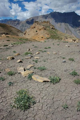 Old abandoned gompa
  Shipyard DDE ...
Topo: absolutely great to walk over towards Kaza Langja and villages and the monastery of Hikkim Komic leaving the luggage at the guesthouse (it climbs even when dry difficult to do while "Fully-loaded"). It is therefore the parties with the minimum 2 days (sleeping bag, a fleece for the evening, a flashlight, toiletries reduced, a picnic and some water).
Altitude starting Kaza: 3722m.
Just outside of Kaza (Losar direction), the first road on the right. It quickly became a runway.
Km 7 (alt 3996m): 1 track from Hikkim right direction, the other vaguely straight left towards Langja. We chose to go by Langja, softer, more progressive.

Km 13 (alt 4249m): Langja
Several possible camping spots above Langja (groups of trekkers when it is past, pity they do not always report their waste ...). Then, it continues to climb to the Monastery of Komic (4500m), with Cho Cho Kang Nilda (6300m) in the background.
KM 15: it goes not far from the village of Hikkim

Km 20: Junction with track Direct Kaza
Km 25: Monastery Komic (alt 4500 and dust, forgotten to record the exact statement)
After the monastery, the trail continues towards a pass (alt 4662m, Km 2.5) and several villages. We've only been to the pass because we planned to sleep at the monastery.
It must be a way to make nice loops:
- Komic - Demula (26 km) - Lidang (12 km Demula) - return via Thiego Kaza (12 km), a fifty km in total of According to information from the monk Komic.
- also been Hikkim: Shilla Jot (pass at 5670m according to the map Leomann Maps) - Lashitang - Lalung - Kaza in 2-3 days after the guy from the agency at the center of Kaza. Learn about space on the route and distances, but that's part of pure mountain biking (Ecosphere to Kaza organizes mountain biking in the corner and should probably be able to learn).
can sleep at the monastery of Komic (double base, bucket shower, toilet "in the open"). Also in homestays (ask at the assoc "Ecosphere Spiti" in Kaza).

Komic Since there is a nice hike that descends to Kaza in 3 hours (or even blog last year), but not cycling (too steep cliff of Ras qqs passages).
 picture of the trip we made in 2007
 We resdecendues by Hikkim, passing in front of the old Gompa (ruins). Very nice scenery but difficult track, steep in places (glad to have it down and not up). Komic - Kaza via Hikkim: 20 km. It's definitely worth going up there. Saying it would be extremely unfortunate to go to Kaza and not wander in the villages immediately above.
 Tar slowly given the technical means ...!


